


Mogo: what is being said, and not said
- The Beagle

- May 17, 2021
- 9 min read
Eurobodalla Mayor Liz Innes advised, in her response to recent criticism on social media, saying "the fires had provided an opportunity for Council to reassess Mogo’s infrastructure."
“The village deserves well-planned facilities for residents and visitors,” she said.
“To that end, we’re spending bushfire recovery funding on town planning, collaborating with Mogo’s community to find the best results for the whole village, including infrastructure like toilets, parks, parking, picnic tables and barbecues,” she said.
It isn't clear if the intention of the Bushfire Recovery Funding was that it be spent on town planning, especially given that the new Mogo Village Place Activation Plan is in addition to the Mogo Rebuild Study undertaken in 2020 and the Mogo Village Commercial Centre Development Control Plan (DCP) of 2018 that identified back then a need for a vision (and action) for a town plan for Mogo.
In fact the Council and Mogo has been at loggerheads for more than three decades over the facilities it has provided (or not) and the standard of the infrastructure. Treatments to footpaths have been piecemeal and the recent improvements to carparking and Annett Street reconstruction are long overdue.
More recently Council announced it was going to improve pedestrian access between the town and the sportsfield using left over Bushfire Recovery funding from elsewhere. This may have brought a smile to those who have been lobbying for years for a footpath between the school and the residential area to the south west of the town.
Many in the community have, however, suggested that council simply used Bushfire Recovery Funding money to attend to fast track the community infrastructure it had already identified committed to under its Eurobodalla Pathway Strategy 2017.
Note that in its Eurobodalla Pathway Strategy 2017 Council said :
"Council is responsible for an existing network of 108.5km of footpaths and shared paths across Eurobodalla with a gross replacement cost estimated at $30.8 million. Despite this Council has many existing urban areas that do not have a formal network of pathways. This is a significant gap in our infrastructure with Council receiving numerous requests to provide pathways. To address this gap, Council has allocated $3.5 million in its long-term financial plan over the next 10 years [2027] to develop high priority sections of the pathway network."
The footpath (Church Street to Park Street) in Mogo that Council has now committed Bushfire Recovery money to was NOT identified in the 2017 Strategy as HIGH.

Above: Has Council used Bushfire Recovery Funding money to provide a facility that it had already committed to and declared a medium priority to be attended to after 2027?
It is noted that the estimated cost, in 2017, of the 210 metres of pathway is estimated at $33,500 (see table above).
Curiously the Mayor, in her Mayoral Minute that fast tracked the Medium ranked pathway to a high priority, indicates the works for the a footpath that connects the Mogo Village with the Mogo oval and playground will receive $115,000 of Disaster Recovery Funding – Commonwealth Government, Councils Affected by Bushfires’ funding provided by the Australian Government through the National Bushfire Recovery Agency.
Nearly four times the estimate of four years ago.

The latest Mogo Village Place Activation Plan is due to be finished in the next six months.
The diagram below has raised concerns with locals wanting to know why Council have increased the boundaries of their future planning to include the area south of Tomakin Road.
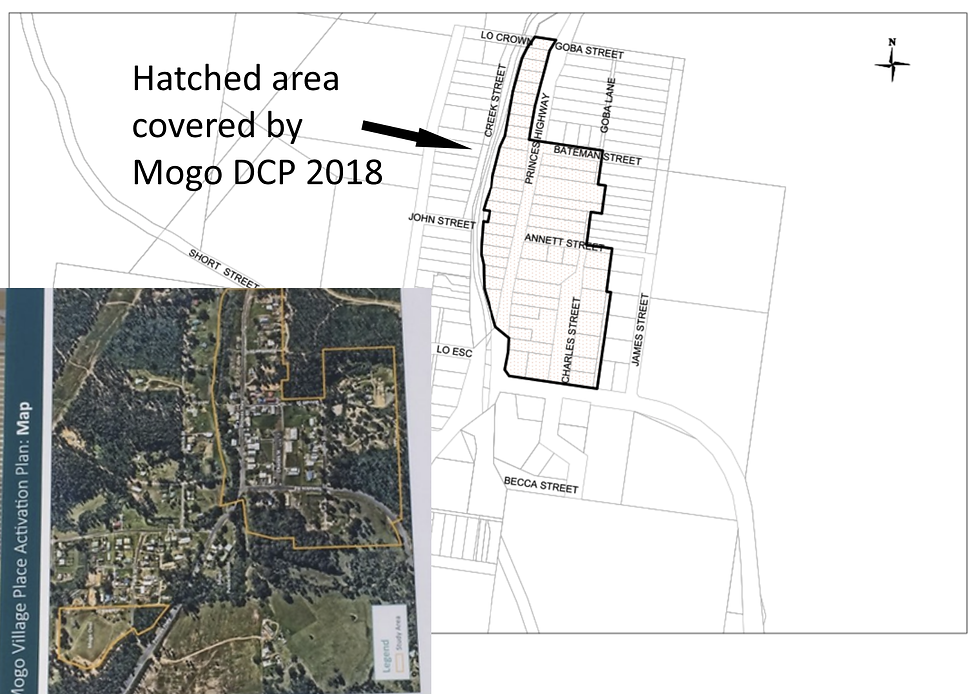
Above: Note the difference in the size of the two Plan areas. What does Council have in mind for the south side of Tomakin Road? What do they have in mind for the eastern side of James Street?
Council has engaged Ethos Urban to prepare a Mogo Village Place Activation Plan saying "with input from the community, the plan aims to develop strategies, actions and/or projects that will further activate the local economy, strengthen community resilience and reinforce Mogo as a key destination after the 2019-20 bushfires.
They say that the Mogo Village Place Activation Plan will provide a clear vision for Mogo yet they have not advised the community of all the facts.
Council say that the plan will "bring together and coordinate planned projects proposed for Mogo Village" yet fail to take responsibility for initiating, without any community consultation, the plan to have a Mogo Adventure park that will bring 45,000 cyclist to the town every year.
While such a facility might read well the practicality of parking, road safety and public toilets needs to have the whole community involved.
In the case of the Mogo Adventure park the community were informed at the same time as the wider community and invited to make their own submissions.
Now the community is learning that Tomakin Road is earmarked as a major distributor road linking the Princes Highway to the coast with Council saying that traffic is expected to increase significantly as Broulee, Tomakin and Rosedale develop further and visitor numbers rise.
Approximately 1.5km of the 6km long Tomakin Road has been upgraded in recent years. The NSW Government has now committed funding over the next three years to allow Council to bring the whole of Tomakin Road up to a standard appropriate for a major distributor road.
Once this fact is on the table it becomes clear as to why Council are currently seeking funding to build a roundabout on Tomakin Road at the Charles Street carpark entrance that can accommodate 26m long B Doubles.

Above: Why would Council want to have B-Doubles turning off the highway into Tomakin Road? Image above extracted from a proposed Council PLAN 3864
The NSW government are predicting a 15% increase in regional population by 2031 and predict freight movements to double. Part of that plan is to increase the capacities of the roads to service 26m B-Doubles. The justifications around the replacement of the Batemans Bay Bridge included its inability to carry B-doubles.
Eurobodalla remains one of the few shires in the NSW without any access for 26m B-double transport vehicles. This places Eurobodalla in a 'black hole' when potential business investors look to establish commercial ventures
In order to extend that range south of Batemans Bay the RMS will have to look closely at two pinch points. Mogo and Moruya.
The Moruya by-pass is already on the design table. The new bypass will have the capacity to carry B-Doubles with a new bridge proposed east of the township that will connect the highway just north of the Moruya Industrial Area to Noads Road in the south where it will rejoin the highway.
This route will run to the eastern boundary of the new Eurobodalla Regional Hospital. Whilst not formally signed off the plans on exhibition of a preferred route offer a reasonable assumption.
Mogo offers up a different problem all together for B-Doubles.
The 2017 Eurobodalla Shire Council Submission to the Future Transport Strategy states "The timing of the by-pass at Mogo is anticipated to be medium to long term and will depend on the short term solution provided to widen Mogo bridge and provision of a suitable intersection treatment at the Princes Highway/Tomakin Road intersection."
The Council authored 2017 Strategy states:
"Within the 40 year planning horizon of the NSW Transport Masterplan, it is inevitable that the standard of highway south of Nowra to the Victorian border will need to move to freeway standard to service the growth over time. That is, a standard similar to that being constructed now between Gerrigong and Berry will be required.
"For the highway to be effective long term, the RMS must work closely with Councils to provide integrated transport solutions. The effectiveness of the current Princes Highway to perform as a primary transport corridor is significantly hampered by strip development along the highway frontage."
As the Batemans Bay Bridge project approaches its completion the next focus for road improvements in the Eurobodalla will be the proposed roundabout on the Princes Highway south of Batemans Bay that will see the last section of the "Spine Road" constructed and connected to the highway allowing residents and visitors to bypass Batemans Bay and hopefully reduce traffic volumes on Beach Road.
Over recent years considerable effort has been made in improving George Bass Drive.
In the The 2017 Eurobodalla Shire Council Submission to the Future Transport Strategy Council states:
"George Bass Drive is a Regional Road connecting Batemans Bay to Moruya Airport and onto Moruya via North Head Drive. This is the primary road connecting all coastal villages and towns along the coast between Batemans Bay and Moruya. This road services the primary growth areas in Batemans Bay. Another major thoroughfare, George Bass Drive, a 30km coastal road from Batemans Bay to Moruya, is also a priority for infrastructure improvements to improve safety and reduce congestion now and into the future."
With the rapid strip development that is now occurring along the coast from Sunshine Bay to Malua Bay, the proposed 1000 lot subdivision at Rosedale South and the expansion of Broulee and Mossy Point (Oaks Ranch development) it makes sense that Council is steadily bringing George Bass Drive and Tomakin Road up to a standard worthy of a primary regional distributor.
But the elephant in the room remains Mogo. Moruya is now set on a path of having a bypass to overcome the pinch point of Vulcan Street and its lights and roundabouts.
But what of Mogo?
Council in 2017 suggested in their Strategy that, in the short-medium term, the RMS should continue to deliver upgrades to the existing Princes Highway offering a preliminary list of works that should be addressed in the short term that included Princes Highway, Mogo – pedestrian activated traffic lights and Princes Highway, Mogo – bridge widening and intersection upgrade Tomakin Road.
The Council revealed in that Strategy that "the timing of the by-pass at Mogo is anticipated to be medium to long term and will depend on the short term solution provided to widen Mogo bridge and provision of a suitable intersection treatment at the Princes Highway/Tomakin Road intersection."
The new Batemans Bay bridge is theoretically now open to 26m B Doubles as the new design allows such loads.
The key priority for bringing Eurobodalla transport infrastructure in line with current needs was to ensure full B-double access on both the Princes and King Highways yet there is currently no 26m B-double access to Eurobodalla via either of these routes irrespective that one of the primary justifications for replacing the old Batemans Bay Bridge was that it was not rated for a 26 B-Doubles and thereby impacted on the economic potential of the area.
Council have advised that their understanding is that 19m B-double and semi-trailers can already access Tomakin Road and that Council has been advocating to the NSW Government to upgrade the Princes Highway to enable larger 26m B-doubles to access the Eurobodalla saying "The new Batemans Bay bridge is now designed specifically to cater for the higher weights associated with larger B-double transport and the recent George Bass Drive/Tomakin Road intersection design makes provision for 26m B-doubles to manoeuvre through.
Council has offered an assurity, for the present, that "There are no proposals to divert heavy vehicles off the Princes Highway which will remain the primary heavy vehicle transport route to and through Eurobodalla, but as part of planning for the future, other major routes are being designed to make provision for the option larger transport vehicles to access businesses and ensure transport efficiency, road safety and network resilience."

Above: Extract from the RMS HML map showing the allowable routes for 26m B - Doubles as at 30/4/2021
Council claims that the Mogo Village Place Activation Plan, with input from the community, aims to develop strategies, actions and/or projects that will further activate the local economy and strengthen community resilience yet appears to fail in revealing, via the current Mogo Village Place Activation Plan community engagement process, the big picture of the role the Tomakin Road will play as a key distributor feeding an ever increasing strip population from the coast to the Princes Highway, and what they have in mind for the broader areas of the township that are now included to be "activated".
And where will the bypass go?
Of interest the PRINCES HIGHWAY CORRIDOR STRATEGY AUGUST 2016 (p66.) states:
"A closer examination of Section 11 of the corridor between Cranbrook Road, South Batemans Bay and Toose Street, Moruya indicates that the northern component of this 24.4 kilometre section has a poor casualty crash rate. Specifically, the 7.3 kilometre length between Cranbrook Road, South Batemans Bay and Dog Trap Road, Mogo has experienced 38 or approximately 56% of the total crashes along this section of the highway resulting in 20 injury crashes with a total of 30 injuries.
This 7.3 kilometre length of the highway is characterised by a number of deficient horizontal curves often in combination with steeper vertical grades, narrow shoulders and limited clear zones. These alignment concerns are reflected in the crash statistics that indicate that 60% of the crashes reported on this section of the highway are “off road on curve” and “off road on curve hit object” crashes.
The majority of these crashes (87%) have occurred in the 4 kilometre section south of Cranbrook Road to a point 1 kilometre north of Runnyford Road.
In 2014 the NSW Government announced a $10 million funding commitment to Eurobodalla Shire Council for the construction of the South Batemans Bay Link Road. The Council proposed link road is being constructed to take pressure off the existing Beach Road/Princes Highway junction and to accommodate future growth in land use both within the existing urban centre as well as in coastal towns accessed via Beach Road. The link road is expected to be open to traffic by 2017."
While Council have indicated they are keen to see improvements to the "Mad Mile" (being that steep section of the Princes Highway south of Batemans Bay the degree of difficulty and considerable cost in providing a solution to the bends and gradient will keep the work in the too hard basket for years to come.
This presents a further problem to the prospect of running 26m B-Doubles along this section of highway, as was identified in the PRINCES HIGHWAY CORRIDOR STRATEGY AUGUST 2016
