


Is Council walking away from another PUBLIC Road under its control
- The Beagle

- Mar 2, 2021
- 5 min read
It appears, via a systematic approach of stealth by inches that the Eurobodalla Council has gone from maintaining and promoting the Wagonga Scenic Drive as a must see Tourist Drive that skirted the very scenic Wagonga Inlet to divesting all responsibility of it and handing it, a Public Road, to Forestry without consulting with the public. In March 2019 The Beagle asked "What happened to Wagonga Scenic Drive?"
The Beagle's interest was raised by to a letter to the editor drawing attention to the closure of the northern section of Wagonga Scenic Dr that surrounds Wagonga inlet Narooma.
Bill Braines advised, at the time, that he had made exhaustive attempts to establish why this northern section had been closed. He also wrote to advise council's refusal to explain to him why they won't maintain it.
Mr Braines wrote that the road loop had always historically been graded by Eurobodalla Council for more than 30 years and, until the last decade, signposted as a Tourist Route that provided a route around Wagonga Scenic Drive linking Kianga Forest Road, Box Cutting Road and Wagonga Scenic Drive .


Above: NOTE that Wagonga Scenic Route and Box Cutting Road that connects to Kianga Forest Road, joining at Makins Hill IS PUBLIC ROAD under Council care and control.
Images: https://maps.six.nsw.gov.au/
It was observed by Mr Braines that a bridge along this section "was somehow left out" of the shire bridge reconstructions that were carried out on the rest of Scenic Drive some years ago under a State Gov grant.
It was noted that around this time the remote section of Box Cutting Road fell into disrepair and all but closed by the actions of Forestry Corp.
Mr Braines asked "How can this once very popular Tourist Route just be closed without public consultation and advice in a fire prone area? In fact the loop still shows up as open on mapping devices, including those used by emergency vehicles. I contacted three fire stations to see if they were aware of the closure and no they hadn't been officially notified."
"Also three state forest tracks terminate on this closed section. Sounds like a recipe for disaster?"
He suggested that the council administration is running elected councillors in circles, and these elected officials are powerless to even be advised of the status of this section of road or why it was closed or how it can be reinstated.
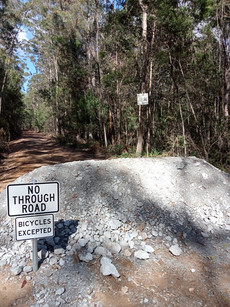
Above: from the Public-Forum presentation 28-August-2018 Mr Braines said at the time (March 2019) "I have approached the General Manager, put a formal presentation to all the councillors at a Council meeting and personally contacted four councillors, all to no avail. I'm still waiting for replies from some, six months ago." Council, for many years also maintained Box Cutting Road which is owned by Forestry,as confirmed from Six Maps and Council's GIS. Council maintained that section of road in return for Forestry graders maintaining other remote Eurobodalla owned public roads. It is understood that this arrangement ceased around a decade ago for a remote section of Box Cutting Road that formed part of the loop. Rather than maintain the section of PUBLIC ROAD between Box Cutting Road and Red Knob Road further north, that includes Makins Bridge, Council decided it would NOT maintain it and allow it to fall into disrepair. It now appears that Forestry are under the impression they own the section of road based on recent activities that have seen Forestry install a series of eight substantial, vehicle blocking, mounds along the section of road and erected BICYCLES ONLY signs as a message to horse riders and motorcyclists. SUCH WORK and SUCH SIGNS are ILLEGAL on a PUBLIC ROAD and whilst COUNCIL might choose NOT to maintain the section of road it REMAINS PUBLIC.

Above: the distances and dates are from Councils 2019 annual Grading Schedule of roads under their care and control. NOTE that a section of PUBLIC Road is NOT maintained.
Forestry rarely maintain roads unless extracting from the forest. In this area they withdrew their own road maintenance some time ago leaving it in what was a barely passable condition. In 2019 it was certainly no longer the once popular Wagonga Scenic Loop that unfortunately still remains promoted in some tourism booklets and on various websites.

Above: 2007 Tourist Route sign in place pointing to the Scenic Drive. Kianga Forest Road

Above: 2010 Tourist Route sign in place. Old Highway Narooma
Council, in charge of endorsing Tourist Routes withdrew its support of the Wagonga Scenic route around 2010 that saw the brown and white tourism signs promoting the Tourist Drive removed. The loop was, until recently, promoted on Council's tourism website but only as a suggested bike trail.
Mr Braines said in his 2019 letter "Before Christmas I related all this to Mr Constance, including the serious wash out that has occurred along this section of road due to no maintenance (see photo below) saying it was a danger to people still using the road,especially in the holiday season."

In Council's adopted Eurobodalla Shire Council – Wayfinding & tourism signage strategy the Wagonga Scenic Drive is stated as no longer an official tourist route because of the condition of the road.

The Strategy cited that the feedback was that this scenic drive should be reinstated advising "It needs to be determined if this is a priority and will result in improved visitor numbers and length of stay."
The recommendations of this strategy advise that Council consider opportunities for tourist drives and scenic routes including:
• Locations such as Wagonga Scenic Drive, the Old Highway and Tuross Head
• Participating in the development of an RMS tourist drive strategy where possible.
• Routes for certain vehicles only (e.g. 4WD).
This week (March 2021) Mr Braines returned to the area to find Forestry undertaking repairs along .


NOTE that the signs for Wagonga Scenic Drive and Red Knob Road have only recently changed - see before and after images below. It is unknown who made this unauthorised signage change on a Public Road:


On August 13th 2019 Eurobodalla advised The Beagle "Council does not maintain the section of Wagonga Scenic Drive north of Box Cutting Road.
Forestry Corporation NSW has confirmed it did traditionally undertake maintenance on
Wagonga Scenic Drive north of Box Cutting Road, including maintenance of the bridge over
Makins Creek. "However, Forestry has now discontinued maintenance of this section of road,
including Makins Bridge, for operational reasons. Forestry has advised that to ensure the
community’s safety, this road has been closed to vehicular traffic by installation of earth
mounds at each end and by erection of a Road Closed sign."
To TRANSLATE Forestry Corporation NSW has confirmed it did traditionally undertake maintenance on A PUBLIC ROAD KNOWN AS Wagonga Scenic Drive north of Box Cutting Road, including maintenance of the PUBLIC BRIDGE over Makins Creek and discontinued maintenance of this section of road, including Makins Bridge, for operational reasons.
The fact of the matter is that the "operational reasons" were because Forestry was NOT allowed to expend funds on NON-FORESTRY assets. The same applied to COUNCIL who were no longer able to expend ratepayers money maintaining assets that were NOT ratepayer assets. It was a matter of law and insurances.
The fact is that Forestry ceased maintaining a PUBLIC ROAD and COUNCIL determined, without ANY public consultation, that it would allow Forestry to erect earth mounds, block a PUBLIC ROAD and walk away from responsibility for a failed bridge that was a PUBLIC Asset.
The Beagle will now request a face to face meeting with Council over the matter.