Councillors attend on-site inspection of failed Araluen Road
- The Beagle

- Apr 7, 2021
- 3 min read
Councillor Pat McGinlay and Anthony Mayne were the only councillors who responded to community invitation to see first hand the failure of the Araluen Road that has sunk to a standard of no longer being fit for purpose.
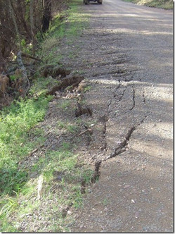
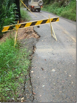
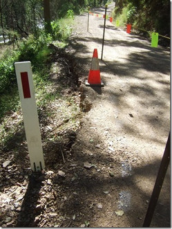
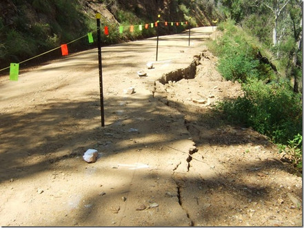
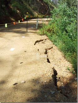
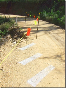
Councillor McGinlay met with over twenty locals at the McGregors Creek Bushfire shed to then visit the many sections of road that have failed west of the landslide. Most of these, from the photos and evidence provided to The Beagle appear to be due to lack of maintenance or by genuine commitment by Eurobodalla Council to maintain what was once an important Main Road through the region.
Meanwhile Councilor Mayne separately visited the landslide section on the Moruya side of the Araluen Road.
Disappointingly none of the other councillors bothered to respond to the personally emailed invitation to meet locals and see for themselves the issues and failures.
The Letter to the Editor published last week looked beyond the localised landslide that Councillors had been briefed on and exposed that there are many other major issues on the road that, having not been addressed over time, have lead to a string of failures that have now rendered the once highly used road, linking the inland to the coast, impassable.
The Araluen Road began its physical decline in the 1990's. Historically it used to be Main Road 271 linking Araluen, Braidwood and the tabelands with the South Coast via Moruya.
The major landslide that occurred on 2nd November 2020 remains in situ, with residents none the wiser as to which option council intends to pursue: remove the debris and reinforce the rock face or construct an alternative route.
It is understood that the suggested alternate route will cost millions.

How did the once noble Araluen Road arrive at such disrepair?
The road between Araluen and Moruya was constructed between 1856-61. In 'Moruya: The First 150 Years' the authors explain: 'The Moruya River is a salt tidal river as far as the Kiora Bridge. From there it takes the name Deua River upstream to its source."
The discovery of gold at Araluen had led to a rush. Within months of its announcement there were 15,000 men in the Araluen Valley. They came to the port at Broulee and walked overland for 50 kilometres to the goldfields via the hand hewn Araluen Road.
Up until the 1990's the road was known as Main Road 271 and received State Government funding. These funds helped pay for the required maintenance of culverts and drainage critical to ensure the stability of the road. The funds also covered the costs of resheeting and grading to keep the surface servicable and, with good management, there was continued improvement of the road with tree removal, batter works and additional drainage installed.
But Council decided in the 1990's that it would reconsider its priorities and lobbied the State Government to change the status of the Araluen Road to a "Local Road" that would then fall under the control and responsibility of Council.
Council lobbied that Hector McWilliam Drive in Tuross Head be recognised instead as a regional road for the purposes of funding & administration so that it might receive annual funding to assist with maintenance & renewal (as does Cullendulla Drive, Beach Road, most of George Bass Drive, North Head Drive, Mort Avenue/part of Noble Pde/Dalmeny Drive & Bermagui Road that are all designated Regional Roads).
It was considered that, although Araluen Road passes from Eurobodalla into Queanbeyan Palerang Regional Council, the very low traffic volumes meant that it was considered as a "local road" and it is still considered by Council as such with staff advising "this will remain a local road".
Steadily the road fell more and more into disrepair. In August 2007 the Araluen Road was identified as a critical location to have restrictions applied to oversize vehicle operation. The road that was once passable for cars with caravans (with caution) had become a narrow guttered formation that had poor surface maintenance and even poorer drainage often rendering it a slippery bog.


Above: little has changed since 2007
It will be of interest to learn what the visiting councillors heard from locals. The following photos of the poor condition of the road came as a surprise to the councillors when they received them as an email sent by a local Deua River resident as the Councillors had only been briefed on the landslide section and were not made aware of the overall poor state of the road further west.