


Coopers Island Road - the law vs the reality
- The Beagle

- Jun 10, 2021
- 13 min read
They say good journalism is to present both sides of the story.
I must admit that to date I have only presented one. The legal aspect, the processes required and the failings of Council to undertake due process.
To recap on the legal side:
Coopers Island Road is a public road that provides access to a public causeway and a crown foreshore reserve. It is illegal to erect a gate on a public road and it is illegal to erect encroaching fencing on a public road and to erect fencing prohibiting access to a Crown foreshore reserve.
The issue at hand is that a Council ranger incorrectly, and without any legal authority, advised the property owners that they could erected a gate across the road at the Princes Highway to prevent cattle jumping the cattle grid.
The owners, in good faith, erected the gate. While it is widely argued that there was a cattle grid present the risk of stock crossing it to the highway was already high with several instances. In the arguments offered it was all too often stated that the grid was poorly maintained and full of mud.
This comment, along with a host of other comments feed social media for nearly two years.
The general cry from the community was "It is a PUBLIC ROAD and our public road and we want the gate removed and have a right to access the weir".
The above is true legally. The above is also the viewpoint I took when I challenged Council that they, as the Roads Authority, through their inaction, their failure to enact legal delegation and their, failure of communication to the public had allowed the issue to fester until it arrived at bursting point with needless confrontations between the farmer and the public.
Today (Jun 10th, 2021) I did what the Councillors and Council staff should have done two years ago. I got off my backside and went and had a proper look for my self.
The first thing I encountered was a cattle grid, in good order.
How do I know it is good order? Because I worked for Eurobodalla Council for twenty one years. During that time I was initially employed in the survey section and then the engineering section where I held the position of Roads Register Officer (required under the Roads Act). In my capacity as Roads Register Officer I kept a register of all Council owned Roads, whether they be maintained or not, and established a full Roads Maintenance System that identified the road, the construction history of the road, the defects on that road and a full register of Council approved cattle grids. Whilst working in Council I was the expert officer in all things road data related.
So how do I now the grid I saw today was in good order and not sub-optimal as widely speculated on social media and in village whispers?
Where the Grid/Gate is on a maintained Council Road and has been constructed to Councils standards and approved for use by Council, the applicant shall be fully responsible for all maintenance and repairs of the gate/grid, signposting and the road approaches either side of the gate/grid.
Where an existing gate/grid is not being maintained to the appropriate standard, Council will serve notice on the occupier/owner to carry out remedial works within 7 days. Failure to comply with the notice will result in the levying of penalties as contained in the Roads Act, or cancellation of the permit. The General Manager may cancel the permit for failure to carry out remedial work or when changes occur to the classification or alignment of the road.
There it is; that is the law. Coopers Island Road cattle grid is a legal installation and meets Council's appropriate standard.

Now we move on to the gate. Well erected and definitely NO lock or any hint of there ever being a lock. The owners advised Council they had posted a sign saying PUBLIC ROAD. While there was no evidence of a sign today there may well have been a sign in the past.

The first thing I noticed was that the electric fence that was temporarily strung between star pickets on the northern side (left in above image) was now removed. It was immediately evident that the electric fences were in place to keep the cows away from the deciduous trees that had been planted in the road corridor.
In all it could be said that there is a section of fence missing on the northern side between the gate and the top of the hill. In all around 290 m of fencing that could be restored (red dash in photo below). Should this be done the Public Road to this point would be fenced on both sides offering a distinct separation of road traffic and livestock.

I observed that from the highway to this point there was quality new fencing on the southern side and that this style of robust fencing continued then on both sides of the road from the top of the hill near the access to the haybales all the way down to the start of the weir.
Council, in their report on the matter offered a surveyors plan that, to 99% of anyone looking at it meant not much at all.

Had they put it in context it would have looked like this:


Sadly Council doesn't have a registered surveyor any longer. If they did this would all have been dealt with two years ago. The minor encroachments of fencing to the road formation of Coopers Island Road have been identified and actioned for over thirty years.
All that was required two years ago when senior Council officials first heard that a ranger had provided, without authority, verbal approval to erect a gate was to advise the councillors of the issue so as to put in place a timely response bringing the community and the owners to the table.
Instead it appears that the Council decided to say nothing to the councillors in the hope that it all blew over. This seriously backfired on them and in the end the Councillors copped it in the neck because of staff failings to communicate and to carry our actions granted to them under delegation.
I say it again. The owners erected the gate in good faith based on verbal advice from a Council ranger who, unknown to them, had no authority to give such permission. In their submission the owners state: "The planning department gave verbal approval to erect the gate under section 128 of the roads act provided we obtained a survey to ensure the gate was correctly located."
At this point it would be worthwhile introducing the following video.
Having watched the video i is hoped that you are far more enlightened as to what Coopers Island Road and weir looks like.
While it is fair to argue the legalities of Public Roads the video above hopefully shows the road in the context that it dissects an active farm and that the road also plays its critical role in providing vehicular and stock access from one section of the farm to the other.
Today I met my first wagyu cows. And they were unlike any I had met before in years of surveying around the ACT and South Coast. The herd I encountered were at the top of the hill, waiting to be let in to a paddock for afternoon feeding. While they appeared docile I approached them in my car at less than walking speed recognising that they were suspicious and flighty.
They let me drive by very slowly and I continued along the road formation from the top of the hill down to the causeway and Bowns Creek.
It is worth noting that the road reserve is only 10.06 metres wide. This explains why the physical road is sometimes outside of the legal boundary lines and vice versa. The road was constructed generally in the right spot but over 100 years of use it has moved about based on maintenance and grading.
The Council is responsible for the maintenance of Coopers Island Road and have it scheduled for an annual grade every year in April. The grading removes any deformities and reinstates drainage to reduce damage from rains.
Council advised the community in their report on Tuesday of two interesting things.
"Vehicles can turn around within a 10 metre road reserve. At present this is restricted due to the fencing, erected without Council approval by the property owner, that does not align with the road reserve."
Like everyone else I read this and took this as fact. Today I tested it. While it is true that "Vehicles can turn around within a 10 metre road reserve" in the context of Coopers Island Road there are only three spots you can turn around due to the crowned road formation and drainage. The first is at the top of the hill, the second at the bottom driveway into a house block and the third into and adjacent area to the Crown Road reserve that "does not align with the road reserve".
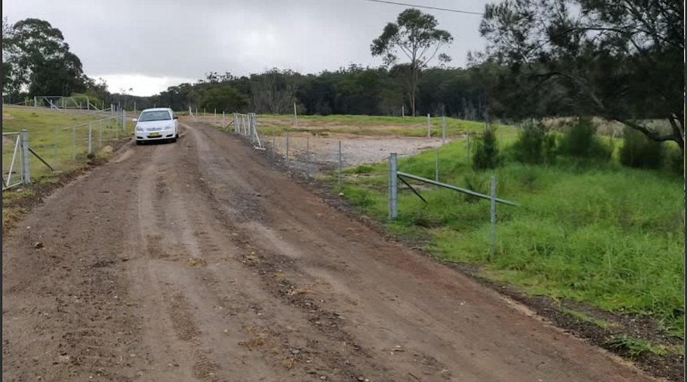
Above: "Vehicles can turn around within a 10 metre road reserve" if they do a five point turn and they are a Toyota Corolla. Note the fenced in triangle - this is where the actual legal boundary of the road is (see pink section below) however it was never formed. Legally the Corolla is parked on the farmers land.
In the past this area was also maintained by Council allowing the Grader to turn around. Since the new fencing was installed the grader has not been able to attend to the annual maintenance.
Council states "Maintenance has not been able to be carried out since April 2019 because the turning space for graders has been restricted due to the fencing near the causeway. Maintenance crews will be ready to undertake maintenance works as soon as a way forward is implemented that permits the required movements by the grader."
If the turning space (in pink below) is reinstated this will then allow an area for the public to park and launch their kayaks from.
To this point it might be reasonable to consider the following as an Option:
Reinstate the missing 290 m of fencing on the northern side of the road from the front boundary at the Princes Highway to the top of the hill.
Install a new double gate on this fenceline that would then enable stock to be securely contained in the northern paddock.
With this gate opposite a like gate accessing the southern paddock and hay shed the owner could easily pass his stock, crossing the public road, from one side to the other as is done on Eurobodalla Road.
Remove the bottom fencing, allow the grader to reinstate this area as a turning circle and provide some parking space.
That might all sound good, and simple. But the road reserve from the highway to the weir is only a fraction of the real issue at hand. The movement and the functioning of a farm with stock that moves from paddock to paddock and paddock to sheds.
The owner of the farm is required to walk his stock, sometimes several times a week, from his northern paddocks down the road towards the weir, to then cross the weir and single bridge and enter the main Coopers Island property with its major buildings and sheds.
Below is where the weir begins - a very narrow weir leading to a single lane bridge.


Above: "Detective Senior Constable Steven Heffernan south coast rural crime investigator has met with council staff directly, warning them someone will be killed at this location with pedestrian access continuing amongst a commercial cattle operation. This meeting with council and Constable Heffernan has not been included in the council report."
Owners presentation to Council.
Council say: "While it is not illegal to fish off a bridge, the narrowness of the bridge (4.2M) could raise safety issues with cattle and machinery/vehicles crossing the bridge while people are also on the bridge. Safety issues have been raised by the landowners on several occasions. Ongoing fishing off the bridge, if supported, will need to be managed with education and signage. Council staff have considered the safety issues involved and the necessary measures that could be implemented, including signage."
As I walked along this section a small truck was leaving the farm. Even though it was only a small truck I had to retreat several metres along the weir to find a point on the bank where I was out of the way to allow the truck to pass.
In the report to Councillors on Tuesday it stated "The owners have also raised several issues including that visitors fish from the bridge preventing access by trucks.... impede stock movements and interfere with farm operations. Currently there is potential conflict with the movement of cattle. The owners maintain that cattle will not cross the causeway if people are in their line of sight, affecting the mustering of stock between paddocks."
Standing on this narrow weir, having walked a fair distance from my car I could see that if I was fishing on the bridge I would very much be in the way of herding and any transport movements.
Had there been a tractor moving hay bales, had there been a cattle truck arrive or if the herd was on the move I would have been well and truly in the way. In the past when this was a dairy farm it may not have been an issue. tractors were smaller, hay was in smaller bales on trailers and the herd were very laid back dairy and not the flightish wagyu I had just met.
The staff offered the Councillors, at the eleventh hour and 59th minute, a motion that introduced new information to them. They were caught off guard. Such a ploy can only be called untoward as the fourteen speakers who presented on what they thought was the agenda and the motion at hand discovered that the staff had busily rewritten the motion on the fly catching both the councillors and the community out.
The rewrite of the motion was based around information that the electric fence at the front of the property was now removed. This theoretically (though arguably) introduced the option that the owner could now formally seek a Gate Permit. Note: While the road reserve is already fenced for 290 metres on one side the application will most likely fail.
Never the less the Council staff "played a swifty" at the eleventh hour thinking this might be a way of legally retaining the controversial gate.
Today I saw another option.
In the presentation by the owner to Councillors the other day it was stated "The private property sign is there to obviously deter people from walking through paddocks, excreting and trespassing on private property which has occurred, this is documented in several police reports and is a biosecurity risk to the farm operations. There is a biosecurity plan in place."
For nearly two years I have heard from members of the community who tell me it is their legal right to drive along Coopers Island Road. It is their legal right to park at the end, to launch kayaks, to come ashore in their boats to this spot, to fish off the weir and to prawn off the bridge. I have heard it is their right to have a picnic on the shore and even to set up banana chairs and a gas cooker for cups of tea on the weir to fish for the night.
"Its my right its a public owned road, i pay my rates, and it is being taken away from me".
The issue of Coopers Island Road is NOT the gate, but the gate represents the issue perfectly.
Today I arrived at a working farm. I was met with a cattle grid and a well built gate. With respect and caution for animals I entered, being sure to secure the gate behind me.
I saw cattle at the top of the hill making their way across the public road from one paddock to another, as is their legal right. I slowed to an absolute crawl to ensure the animals were comfortable.
I than travelled along the road to the weir. I did so with caution respecting I was travelling through a working farm and acknowledging I could encounter more stock or machinery.
I stopped and looked over the area known as The Turning Circle and noted remnants of garbage, either left behind or brought to the site with the tides and floods.
And today I experienced the absolute pinch point of how narrow the causeway and bridge is and the fact that I was in the way of the functions of a working farm.
Today I was also reminded that the farm I was traversing via this Public Road was not just a normal farm but a farm that had premium stock destined for a premium market and as such the concerns around controlling who interfaces with the stock is critical.
Had I arrived today and be met by a Biosecurity Management Plan Sign that advised me to first contact the farmer I would have been happy to oblige, knowing that the farmer would know what I was doing, where I was on his property and would be able to carry out his farming knowing the risks
The suggestion at the end of the day was that there should be a solution found that suited both the farmer and the public. The best place to begin is to come to the table and listen to all sides.
If only Council staff had done so two years ago we would be all the better for it

Above: Recreational users can continue to use the public road Coopers Island Road at Bodalla, to access Bowns Creek.
In their media release Eurobodalla Council states:
Coopers Island Road at Bodalla will remain a public road after Eurobodalla Council decided on Tuesday not to sell the road reserve.
Coopers Island Road has been a public road since the 1930s and is used by the public to access Bowns Creek, a designated “Recreational Fishing Haven” for fishing and kayaking. It also dissects a rural property, formerly used for dairy cattle, now used for Wagyu beef production by its new owners.
The Council earlier this year received a request from the landowner to buy the road reserve, citing conflicts between their Wagyu beef production and its use by recreational users. The property owners erected a gate across the road at the Princes Highway to prevent their cattle jumping the cattle grid, as advised by a Council ranger.
The sale of the land was considered on Tuesday by Councillors, who heard presentations from 13 community members who were opposed, as well as the landowners themselves. Council also received a petition to retain Coopers Island Road signed by more than 200 community members.
On Tuesday Council resolved not to close or sell Coopers Island Road to the property owner and to allocate $40,000 to realign the road back onto the road reserve, as the road itself currently deviates onto private property. Council will also install regulatory and advisory signage in the area.
Council will write to the landowner requesting their fence across the road near the causeway be removed. If they do not comply, Council will remove the fence and relocate it to the correct alignment.
Meanwhile, Council is considering the landowner’s application for the gate at the Princes Highway. Council will make a decision on the application by Tuesday 22 June, until which time the gate can stay.
Council’s General Manager Dr Catherine Dale said recreational users could continue to use the road, with respect to the landowner, who is trying to run a business.
“Yesterday’s decision confirms the landowner must accommodate the fishers’ rights to access and fish on the causeway,” she said.
“Similarly, the fishers and the public must accommodate the landowner’s right to move machinery and drive stock along the road and use it generally.”