


Council and the Local Member fail their community - again : The Bumbo Bridge saga
- The Beagle

- Dec 3, 2021
- 18 min read
Beagle readers might remember the sorry tale of the Bumbo Bridge.
In a quick recap:
Tuross Bridge fell down in 1954. To enable traffic to detour the DMR did some quick repairs to the old Bumbo Bridge that serviced a local farm and dairy. The traffic then detoured over pubic road, the old bridge, through the farm, and then met up with public road again to come around the back Bodalla and cross the Tuross River at Silo Bridge to then enter Bodalla.
It was a big detour but it kept the traffic moving. But the old bridge was only temporary. DMR knew this and, together with the council built a NEW Bumbo Bridge that could take heavier loads. Once built they got on with the job of building the new Tuross Bridge that we enjoy today.
Once the NEW Tuross Bridge was built the NEW Bumbo Bridge was not required. Rather than dismantle it the DMR allowed it to stay up.
The vexing question is "Who owns it".
The DMR were not at liberty to gift the bridge to a private company (The Bodalla Company) so the normal course would be to give the bridge to the local council. Given that Council helped build it that made sense.
Move ahead fifty years and the New Bumbo Bridge is not so new again. The owner of the farm it provided access to is no longer the Bodalla Company. Instead it is a dedicated, committed dairy farmer who purchased the farm and turned it into one of the vital primary production farms the region celebrates.
Little did he realise that when he bought the farm he also bought the new Bumbo Bridge. Oddly it was not mentioned in his title, nor was there any mention in his other legal documents. He knew the bridge was accessed on the northern side by a public road that was under the control of Council. He knew that Council maintained the bridge abutments and he also knew that Council used grant funds to remove flood debris.
The farmer thought that the bridge belonged to Council and there was no documentation he held that indicated otherwise.
Alas the bridge was becoming old and presenting a risk. The farmer asked Council if they could fix their bridge.
What has happened since that day has become a total farce of bureaucratic juggling, bumbling and bullshit.
In a nutshell Council said the bridge wasn't theirs and belonged to the farmer. Therefore the responsibility to repair (or replace the bridge) was solely on the farmer.
The farmer felt this was unjust and presented on two occasions to the Councillors in Public Forum a thorough history of the Bumbo Bridge, new and old. He asked the councillors if they could offer any support in getting to the bottom of who was responsible for, and owned the bridge because he most certainly wasn't the owner.
Council responded by saying that because there was nothing in their records from 1954 about any transfer by DMR to Council it didn't happen.
What did the Councillors do? Nothing. Sadly instead they were advised that the farmer had used social media to highlight the issue and that the information being put out on "social media" was incorrect. The "social media" being referred to was The Beagle and the issue was being raised in The Beagle and not on "social media".
This information, given to councillors, was designed to discredit the documentation that was being presented to Council to prove the ownership of the bridge was NOT with the farmer. Council even sunk to the point of advising staff not to engage with the farmer, not to talk with the media and to not attend Bumbo Bridge in a Council vehicle or in a Council uniform.
Trying to bring some sanity to the issue the Member for Bega, Andrew Constance was written to. Sadly there was no response.
The farmer was on his own with a failing bridge, a dairy contract to fill and employees and financial obligations to satisfy.
It is with pleasure that we can announce that there is a NEW Bumbo Bridge. What isn't a pleasure to announce is that the farmer had to pay $700,000 for the bridge from his own pocket.
"Does the bridge now belong to the farmer?" No.
Council have celebrated the new bridge being opened advising that it (the bridge) will continue to provide an alternate route for traffic in the case flood or bushfires, as it has done for the past fifty years.
So Council did all they could to disprove (without actually being able to) that they owned the bridge. Rather than help the farmer who was in a definite plight all of the councillors and the staff turned their back on him and said it wasn't their problem.
The RMS also said they had no records and to consult with Council who they believed should be the owner. When a letter was made with the Local Member to help there was no response.
With no option, with no support, the farmer built a new bridge after submitting a DA as the applicant, paying the fees, doing all the paper work, waiting for approvals from Fisheries and Maritime and then finally constructing the bridge.
It took just five weeks with the loss of just one day's milking. Built by a private company the bridge should last beyond the next fifty years.
"But who owns it?"
It turns out that, once built, the Crown stepped in and has said "Thanks very much, we own the bridge that you have built - and you need to pay us rent to use it".

Not only does the Crown own the bridge and the farmer has to pay an annual rental fee the farmer is required to keep the bridge in good repair and keep "The Premises" clean and tidy. No doubt this puts the onus on the farmer to cover the cost of removing debris from the bridge following a flood. So there you have it - the disgusting tale of Council turning its back on a local farmer, the Local Member not even bothering to respond, the RMS saying it wasn't theirs because they couldn't find a paper trail and the Crown stepping in, after the farmer built the bridge to say "Thank you, nw you have to pay rent". What follows is the sordid story in detail: A Bodalla landowner and the Eurobodalla Council came to loggerheads over who was responsible for the Bumbo Bridge that was urgently in need of repair. Council said it had no responsibility for it yet failed in due diligence to prove it. In the opinion of the State Government Roads and Maritime as per a GIPA request of October 2018 the road providing access to the bridge known as Bumbo Bridge is in the ownership of Council. From that point on Council claims no responsibility.

Above: The GIPA request clearly shows ownership of the road leading to the Bumbo Bridge as Council's

From the above it is confirmed that Council owns to the northern abutment of the Bumbo Bridge
Across the Bumbo Bridge on the southern shores of Bumbo Creek is Riverview Farm with a road that leads to Silo Farm Bridge and loops back to Bodalla via Redex Road.
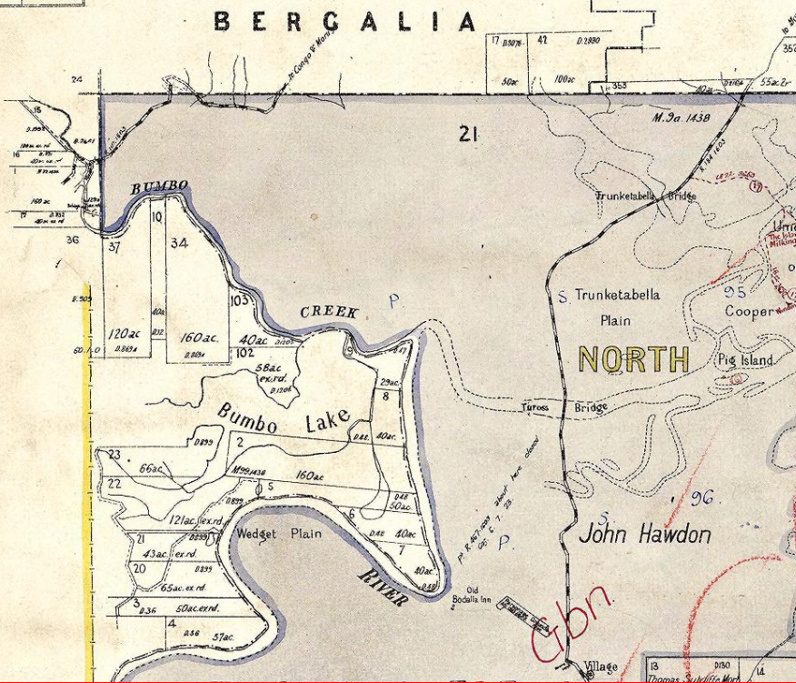
Above: 1918 showing Redex Road in the south west

Above: The original Parish Plans of Bodalla do not indicate any Public Roads traversing Riverview Farm connecting with Redex Road in the west below Bumbo Lake. This however did not stop the DMR from detouring the highway traffic through the farm for months on end over a 10 ton limit bridge they built crossing Bumbo Creek following the Tuross Bridge collapsed in 1954
Riverview Farm has been a dairy for over 150 years. It is now a family owned with a spend in the Eurobodalla Shire area in excess of $550,000 annually employing 3 staff. Access to the farm is from Bumbo Road and across Bumbo Bridge via the Public Road reserve known as Lot 1 and Lot 2 of DP327858. Council received this road reserve from the Bodalla Company Limited in 1931.

Above: The reason for the purchase was to place into council’s ownership the road and bridge access as demonstrated in the letter from Councillor Jeffery Bate to the Shire Clerk dated 6 November 1930 where he states that “with reference to proposed road to Bridges bridge to Riverview. I have made full enquiries and those concerned are agreeable to put in order and to give over to Council.” It was 13 months later that the deeds for the transfer of the 2 Lots that contained the road were registered. The deeds were received and accepted by Council as noted in the Council Meeting Minutes dated 6/7/1932 (Page 381 #328).


The Bumbo Creek bridge, also referred to as Riverview Bridge and Redex Bridge, starts at its northern end with an abutment contained within Lots 1 and 2 in DP327858, which is owned by the Eurobodalla Shire Council, and as such, that abutment is under the care and control of Council and if it was to fail Council would be responsible. What of the rest of the Bumbo Bridge structure? Who is responsible for it? Who built it?

In 1954 when the Tuross River Bridge on the Princes Highway collapsed, traffic was detoured over the Bumbo Creek Bridge and through Riverview Farm via Redex Road. The old Bumbo Creek bridge had its supports strengthened by the DMR and Council so it could be used until the DMR and Eurobodalla Shire Council completed construction of the new Bumbo Creek Bridge so that traffic up to 10 tonnes could use the Bridge and Redex Road as a detour for the Princes Highway until a low-level bridge crossing the Tuross River could be constructed. The DMR under the State Government built it.


Above: Tuross River Bridge collapse 1954 In May 1954 the Department of Main Roads (DMR) wrote to Council thanking them for the co-operation and assistance give in connection with construction of detour and temporary bridge (Bumbo Bridge). This was minuted May 18th, 1954, as can be seen below. From this minute is is more than evident that the Department of Main Roads built the bridge and that Eurobodalla Council assisted.

Council maintained the Bumbo Bridge after its construction and after the new Tuross Head bridge was re-opened (April 10th 1954) as is evidenced in the Council minutes dated 20/7/1954 (below). By their actions it indicates that Council had taken responsibility for maintenance at Council's expense.

While the Bumbo Bridge was used in 1954 as a detour for a State Highway it now continues to be used as an essential access in times of flood by the public at large and not just as private bridge to service the Riverview Farm. The Bridge has used many a time by tourists as an emergency route when they have been caught out by the floods and were cut off as all the bridges up stream became impassable due to the rising river. Redex Road may no longer be a legal Public Road in its entirety however it is shown as a functioning road on all the local road and forestry maps and still functions as a back road used by locals and tourists alike. It is important to remember that the Bumbo Bridge is NOT located on the land owned by Riverview Farm.

The above title clearly indicates that Lot 9 (originally Potion 9) of DP752132 is described by metes and bounds defining the trace lines of water/land, with clear terminal points and angles. Metes and bounds defines the earlier way of describing land by listing the compass directions and distances of the boundaries as is the case with this 1864 Title. By the Crown Lands Act 1989 No 6 -172 Land with boundaries to lakes, roads etc 5) A person is not, by being the owner of land sold, leased or otherwise disposed of under this Act or the Crown Lands (Continued Tenures) Act 1989: (a) as bounded by, by reference to, or by the margin or bank of, a river, or (b) by metes expressed or shown to run to a river or to the margin or bank of a river, entitled to any rights of access over, or to the use of, any part of the bed of the river. As such a bridge constructed by the DMR in 1954, accessed from the north by a Public Road and crossing a river under Crown control and well away from any property boundary can not be granted exclusive rights to that nearby property clearly defined by metes and bounds. What this reveals is that the boundaries of Lot 9 are absolute and not variable depending on the centre line of the creek or the height of high water in the creek. Even by Council's own Geographical Information System it is immediately clear that the river course has changed considerably since 1894 and that the parcel of land known as Lot 9 DP752132 is well removed from the current creek which means that the ownership of the "land" that the bridge is located on is in fact sitting within original river bed. Council might find, if the boundary pegs of Lot 9 DP752132 were reinstated that not only are they responsible for the bridge and its abutments but they are also responsible for the road formation that is located south of the bridge. The only way to verify where Lot 9 DP752132 sits in relation to the creek and bridge is by way of a survey by a Registered Surveyor.

Above: this image from Councils GIS that indicates there has been considerable change in the path of Bumbo Creek since 1854 (Image acquired under Fair Dealing) Note that there is a considerable difference between the 1864 boundary and the current Bumbo Creek shoreline. Under the Doctrine of Accretion Council's surveyor must furnish a report indicating whether the change in position of the river is due to :a gradual and imperceptible movement by natural means or by a sudden shift, as would happen in flood time.
Note above that the bridge straddles a narrow creek. That bridge was built in 1954 adjacent to an earlier bridge the same length constructed in 1934 as accessed by the newly created Public Road reserves in 1931. Both of those bridges arrive at abutments on the southern shore well north of the 1864 portion as described by Title. The southern abutment is approx 150m from the the boundary of Lot 9 DP752132 For the boundary to move 140m in 90 years it would need to average 1.5m per year which could NOT be deemed gradual and imperceptible movement by natural means which is what is required if Council wishes to argue that the bridge is on private land.

The other explanation for the considerable distance from the bridge to the northern boundary of Lot 9 DP752132 is that the soil arrived by way of flood. Possibly the great flood of 1870?

Above: Maybe the NOT-SO gradual and imperceptible accretion arrived in 1934 when the old Bumbo Bridge was built (following the flood?) or the sediment arrived in 1925 which also set a record. What is clear is that gradual and imperceptible accretion of 1.5m does not come into play here.

FACT: The Bumbo Bridge IS located over Bumbo Creek that is under the care and control of Roads and Maritime. Fact: The Bumbo Bridge IS accessed via a dedicated public road owned by Council that arrives at its northern abutment and from there crosses a river that must either be under the control of the State or ..... be private property. In this case this bridge is certainly NOT Private Property as records clearly prove it was built by the DMR for PUBLIC use and was then maintained by Council. It is also important to remember that a bridge consists of a deck, piers, girders, corbels and two abutments - whoever owns the bridge owns ALL of those components. So who owns the bridge?


Above: Bumbo Bridge
If any accident was to occur on the bridge who would be responsible? The Owner. Council might argue that the bridge serves as the access to Riverview Farm alone however Bumbo Bridge is not only used as access to Riverview Farm but also provides flood access to two other farms and is used by hundreds of locals and tourists in a year for access to the creek and river for fishing or for those exploring inland via the vast tract of forestry roads. It is important for Eurobodalla Council to realize the role of the Bumbo Bridge plays in providing access during flood times. The road that passes Riverview Farm becomes Redex Rd. Redex Road then joins B Travers Rd and Comerang Forest Rd continuing in an easterly direction past Long Flat and Mortfield, two large dairy farms and then over Silo Farm Bridge to join Eurobodalla Rd. Silo Farm Bridge goes under water in a small flood, making community access to the properties and networks mentioned above through Riverview via Bumbo Bridge essential. In large floods Bumbo Bridge gives access at the beginning and end times as it is the last bridge to go under and the first to come out in flood times. Comerang Forest Rd to the west gives access to Cadgee, Nerrigundah and Belowra districts and the use of Bumbo Bridge with a link to the highway is therefore important in emergencies. From Mortfield the only alternate route to the highway at Western Boundary Rd is over 70kms and takes well over 2 hours depending how much debris has to be cleared on the way. In the case of one local dairy farmer further south of Riverview they farm and live on both sides of the Tuross River, the dairy being on the north side and reached via Silo Farm Bridge. Their dairy staff who live in Bodalla and farmer therefore need to use Bumbo Bridge to help keep the dairy operational in floods and to keep the animals safe. In fact there have been times that family and neighbours would have been cut off from home and the animals when the river rose quickly while they were out, had it not been for the Bumbo Bridge. Unsuspecting tourists have also needed to use the bridge when caught on the forestry roads unaware of local river conditions. It should be noted that the Tuross River has a very large catchment and is prone to flooding well before the Moruya River. Floods can occur, as attested by records, any number of times each year.

So what obligation is there for either the NSW State or Eurobodalla Council to recognise the importance of this bridge from the perspective of farming, emergency and tourism and its role in servicing an alternate road network that serves a vital community role and will do so with more urgency as climate change and increased bush fires threaten our region. The question could be asked "Does Eurobodalla Shire Council have an obligation as a government organisation to take reasonable steps for the care and safety of the people who live, work and visit within its jurisdiction?" While the ownership of the bridge is in limbo with Eurobodalla Council adamant they are not responsible NSW State funding grants go wanting. Excellent grants are available for repairing/replacing bridges such as Bumbo Bridge that not only provide a vital link but also enable the access of essential transport to service the local dairy industry. This funding however is only available if Council accept responsibility for the bridge. By way of comparison Eurobodalla Council first determined in 2007/8 that Crapps Bridge, a little further to the west on Bumbo Road that services just one dairy, was also NOT on in Council's ownership.


However just a few years later Crapps Bridge was added to the Council Asset register following a report to Council that proved it was a Council asset. In that situation the result was reluctantly accepted. Council clearly did not want to own any more bridges. Crapps Bridge was subsequently rebuilt in 2015 by Council taking advantage of a total of $225,000 for bridge condition assessments under the NSW Government’s Fixing Country Roads Program which is largely funded from Restart NSW.

Extract from Council's 2015 Budget Review showing expenditure of $237,614 to rebuild Crapps Bridge
2015 was a good time for timber bridges. The NSW Government were running with a campaign that "a strong regional economy is important for a strong NSW" and they committed to supporting regional infrastructure projects which help get goods from ‘paddock to port’ more efficiently. Eurobodalla Council stated "Fixing Country Roads is about better connecting local and regional roads to state highways and key freight hubs, and is about moving freight around the State more efficiently" So in April 2015 Council endorsed to accept the offers of funding from the NSW Government under their Fixing Country Roads Program to assess the condition, load and capacity assessment for: 1. Six bridges on regional roads and a further Four timber bridges in the Eurobodalla Road area being Crapps Bridge (Bumbo Road), Tyrone Bridge (Tuross River), Cemetery Bridge (Eurobodalla Road) and Silo Farm Bridge (Comerang Forest Road).
Extract from Council's 2015 Budget Review showing expenditure of $237,614 to rebuild Crapps Bridge But this did nothing for Bumbo Bridge as Council was adamant they did not own it so every round of funding saw Bumbo Bridge miss out. Eurobodalla Council is now being asked to consider all the information provided to them here and to move to have the Bumbo Creek bridge acknowledged as a Council responsibility adding it to the Council asset register as they have done with Crapps Bridge. Eurobodalla Council however appears to have be selective in determining what it is legally obliged to maintain. Crapps Bridge straddles a Public Road reserve on both sides of the creek however the Bumbo Road to the bridge fails to provide a complete legal public road access to the farm yet Council annually grades this section of road knowing that it traverses in part private land (see below) A little further afield Eurobodalla Council maintains the northern section of Congo Road and a cattle grid culvert knowing fully well that a substantial length of Congo Road traverses Private Land with the public gaining access to the Congo Village only at the generous discretion of the land owner.

Above: Council grade the brown section of Bumbo Road though it is not PUBLIC ROAD. In 2015 they also determined to rebuild the bridge known as Crapps Bridge having strongly once argued it was not their responsibility.

Above: Evidence that Council is grading a road that it does not own 2018-19 GRADING SCHEDULE FOR UNSEALED ROADS
It may well appear that either Eurobodalla Council or the NSW State have failed in their duty to maintain a bridge and road abutments that comprise a bridge which is contained within the body of land known as Bumbo Creek.

Eurobodalla Council have washed their hands in regards to accepting any responsibility for the bridge yet after the declared natural disaster of the 6-7 December 2014, Eurobodalla Council staff submitted the necessary documentation seeking financial assistance for Bumbo Bridge actions by way of a grant administered by the NSW Roads and Maritime Services (RMS). A ‘declared’ natural disaster allows councils to seek financial assistance grants from the State Government to restore local roads and bridges to the equivalent of the pre-damaged standard. The total cost to restore local roads and bridges was calculated to be $395,500 - In October 2015, RMS offered Council $366,500 in funding assistance. In the report to Council the Director of Engineering, Warren Sharpe advised Councillors that; "The Schedule of Works that required immediate attention after the floods or will be undertaken by Council to restore local roads and bridges to pre-damaged standard" included among a list of other Council owned bridges : Bumbo Bridge access – vegetation washed onto bridge and required removal So while Eurobodalla Council on one hand claims Bumbo Bridge as its own local bridge for Disaster Grant funding it then continues to deny it has any responsibility for the bridge as stated below in a letter date February 1st 2019

Above: Letter written by a Council engineer dated February 1st, 2019 that clearly states that they accept no responsibility as "No records show transfer of ownership was actually completed"
So who built the Bumbo Bridge? The DMR? What evidence is there? What we know is the OLD bridge (no longer there) had its supports strengthened in 1954 and then the DMR completed construction of the new Bumbo Creek Bridge in April 1954 so that traffic up to 10 tonnes could use the Bumbo Bridge and Redex Road as a detour for the Princes Highway until a low-level bridge crossing the Tuross River could be constructed.

Above: Eurobodalla Council claim that this newspaper cutting provides no evidence of who is responsible for the Bumbo Bridge because it is "a newspaper cutting"
FACT: the DMR completed construction of the new Bumbo Creek Bridge in 1954. The bridge was built over a river which clearly means that the DMR gave themselves authority to do so for the purpose of providing a PUBLIC BRIDGE to be used by the PUBLIC as a detour until a new Tuross Bridge was built. Simply because Council can not find records showing transfer of ownership from the DMR to Eurobodalla Council it does not mean that the PUBLIC Bridge built by the DMR belongs to a member of the public. To say the least the expectation would be that Eurobodalla Council, prior to their Feb 2019 response, applied due diligence in researching and determining ownership of Bumbo Bridge with Roads and Maritime by seeking the documentation that would have been required in 1954 to build the bridge and most likely identify the responsibility of ongoing ownership and maintenance once the new Tuross Bridge was finished.
Clearly the DMR were at liberty to remove the Bumbo Bridge they constructed and would have done so if it meant that they had to take responsibility for its maintenance. One can only assume they offered it to Council as a local bridge to which Council agreed else DMR would HAVE removed the bridge as it was no longer required as a temporary State Highway bypass.
Realising this very obvious shortfall it would be expected that Eurobodalla Council might have advised the Roads and Maritime, prior to writing the Feb 2019 letter, that ownership of what is clearly no longer a State bridge had NOT been transferred to Council to become a local bridge. (Keep in mind that Eurobodalla Council clearly identified it as a local bridge under its care for Disaster Funding and received funding for it)
To pass responsibility on to a ratepayer to carry out research to prove that Council have no legal ownership of a bridge clearly built by the DMR; and to state that no further correspondence will be entered into unless new evidence emerges is a disgrace and shows a distinct lack of willingness of Eurobodalla Council to assist a ratepayer, dairy farmer and the wider community to find a solution to a rapidly deteriorating bridge that provides a function and service.
In the 1990's when this Editor worked for Eurobodalla Council Farmer Norman Crapp of Riverview Farm attended a Council meeting and asked that Council repair Bumbo Bridge. Council initially argued they did not own it and had no responsibility leaving the chambers to then return and advise that the bridge was in fact theirs and that they would attend to repairs. In attendance at that meeting were Councillors Allan Brown and Peter Cairney who both voiced their opinion that Council should do what it can to assist local producers get their products to town. A simple investigation of old Council meetings by Council staff would soon reveal what was said.
Sadly Mr Crapp died soon after his attendance at that Council meeting and it appears that the assurity by the Council of the day to take responsibility for a PUBLIC bridge may also have died with him.